Garmin
Regular price
€471.99
Regular price
Sale price
€471.99
Unit price
/
per
Taxes included.
Shipping calculated at checkout.
Couldn't load pickup availability
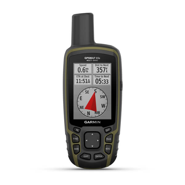
Explore more with this rugged handheld that offers optimal tracking accuracy, a 2.6-inch colour display and preloaded maps.
General |
| PHYSICAL DIMENSIONS |
6.1 x 16.0 x 3.6 cm |
| DISPLAY SIZE |
3.6 x 5.5 cm; 2.6-inch diagonal (6.6 cm) |
| DISPLAY RESOLUTION |
160 x 240 pixels |
| DISPLAY TYPE |
Transflective, 65K colour TFT |
| WEIGHT |
217 g with batteries |
| BATTERY TYPE |
2 AA batteries (not included); NiMH or Lithium recommended |
| BATTERY LIFE |
16 hours |
| WATER RATING |
IPX7 |
| HIGH-SENSITIVITY RECEIVER |
|
| INTERFACE |
High-speed mini USB and NMEA 0183 compatible |
| MEMORY/HISTORY |
16 GB (user space varies based on included mapping) |
Maps & memory |
| PRELOADED MAPS |
Yes (TopoActive Europe; routable) |
| ABILITY TO ADD MAPS |
|
| BASEMAP |
|
| AUTOMATIC ROUTING (TURN BY TURN ROUTING ON ROADS) |
|
| MAP SEGMENTS |
3,000 |
| BIRDSEYE |
250 BirdsEye Imagery files |
| INCLUDES DETAILED HYDROGRAPHIC FEATURES (COASTLINES, LAKE/RIVER SHORELINES, WETLANDS AND PERENNIAL AND SEASONAL STREAMS) |
|
| INCLUDES SEARCHABLE POINTS OF INTERESTS (PARKS, CAMPGROUNDS, SCENIC LOOKOUTS AND PICNIC SITES) |
|
| DISPLAYS NATIONAL, STATE AND LOCAL PARKS, FORESTS, AND WILDERNESS AREAS |
|
| STORAGE AND POWER CAPACITY |
Yes (32 GB max microSD™ card) |
| WAYPOINTS/FAVOURITES/LOCATIONS |
5,000 |
| TRACKS |
200 |
| TRACK LOG |
10,000 points, 200 saved tracks |
| ROUTES |
200, 250 points per route; 50 points auto routing |
Sensors |
| GPS |
|
| GLONASS |
|
| GALILEO |
|
| QZSS |
|
| BAROMETRIC ALTIMETER |
|
| COMPASS |
Yes (tilt-compensated 3-axis) |
| GPS COMPASS (WHILE MOVING) |
|
| MULTI-BAND FREQUENCY SUPPORT |
|
Daily smart features |
| SMART NOTIFICATIONS ON HANDHELD |
|
| VIRB® CAMERA REMOTE |
|
| COMPATIBLE WITH GARMIN CONNECT™ MOBILE |
|
Outdoor recreation |
| POINT-TO-POINT NAVIGATION |
|
| COMPATIBLE WITH BASECAMP™ |
|
| AREA CALCULATION |
|
| HUNT/FISH CALENDAR |
|
| SUN AND MOON INFORMATION |
|
| GEOCACHING-FRIENDLY |
Yes (paperless) |
| CUSTOM MAPS COMPATIBLE |
yes (500 custom map tiles) |
| PICTURE VIEWER |
|
Outdoor applications |
| COMPATIBLE WITH GARMIN EXPLORE™ APP |
|
| GARMIN EXPLORE WEBSITE COMPATIBLE |
|
Connections |
| WIRELESS CONNECTIVITY |
Yes - Bluetooth®, ANT+®
|
Share
View full details