
Harvey
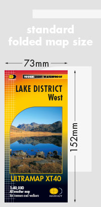
Lake District West
Lake District West
Regular price
€12.98
Regular price
Sale price
€12.98
Unit price
per
Taxes included.
Shipping calculated at checkout.
Couldn't load pickup availability
Description
Covers a large area yet is handily compact. Pocket perfect!
Detailed map for runners and walkers of the western fells of the Lake District National Park at the magic scale of 1:40,000.
Scafell and the Langdale Pikes, and fells west of the Kendal-Keswick road.
Hard Knott and Wrynose Passes. Ennerdale, Wast Water and Coniston Water.
Includes 74 Wainwrights.
Features
- Fully detailed genuine HARVEY mapping
- Includes Rights of Way
- Use without a map case: tough and 100% waterproof
- Opens directly to either side of the sheet
Technical Specification
- Scale: 1:40,000
- Ratio: 2.5cm = 1km
- Flat size: 870 x 304mm
- Folded size: 73 x 152mm
- Weight: 25gms
- Area of mapping: 709sqkm
- Double sided